Moorland Caver(2003)
NGR: SE 582829
Altitude: 150 m
Length: 250 m
Depth: 43 m
Access: Permission to descend is not granted.
Grade: III
Entertainment Value: IV
Warning: The main rift in Antofts appears to still be geologically active. Explorers should be aware of a very real danger from falling boulders and unstable / unconsolidated chokes – you have been warned!
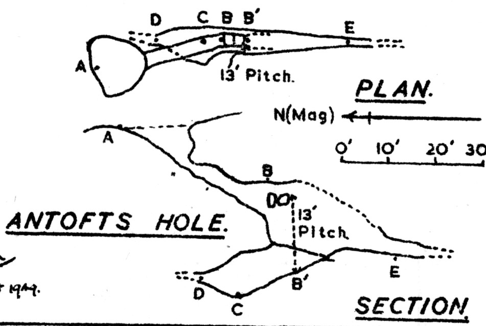
The large, fenced entrance hole leads down a mud slope (beware broken glass) to the head of a descent down into the Main Fissure. From this point two options are available: A 20 m ladder descent from this point (belayed to two 8mm spits – installed in 2003) or a climb down over a boulder to a traverse along a ledge (whilst lined) and down 3 m to a “trapdoor” above the main fissure. Both routes descend through the trapdoor to the main rift. It is possible to free climb from the trapdoor to the main rift, however a 15 m ladder (belayed to two 8 mm spits- installed 1998) is advisable. Various interconnecting boulder chambers and a dangerous high-level traverse along the top of the Main Fissure (not recommended) can be entered in the vicinity of the main descent. Under a large boulder, on the opposite wall from the base of the ladder is a corkscrew climb down to the fissure floor.
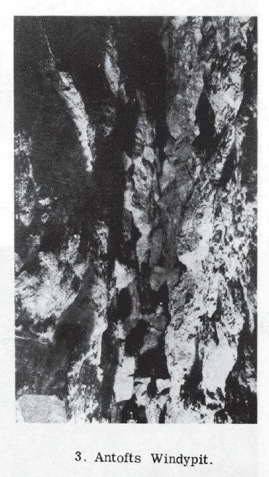
The Main Fissure is one of the most impressive voids under Ryedale, 2.5m wide and up to 22m high. Heading N.W along the Fissure a large and unstable boulder ruckle is reached after about 30m. Just before the ruckle is reached take note of the fresh impact marks on the walls and recently split calcite – evidence that the fissure is worryingly active. Like the fissure the boulder ruckle is also active and it may be necessary to dig ones way through (EXTREME CARE REQUIRED). The usual route through the ruckle is to climb up the face of the ruckle for circa 5m then squeeze through/under/over various loose boulders. Various obscure routes bypass the ruckle including a 10m traverse up the main fissure and over the ruckle (rather exposed) or an 8m long squeeze starting on the right hand side of the main fissure and emerging at the Crossroads on the other side of the ruckle.
Once through/past the ruckle a branch fissure, perpendicular to the Main Fissure is met. The branch fissure is blind, however it does connect with the end of the squeeze which bypasses the ruckle at a cross junction known as The Crossroads. The Main fissure can be followed at various levels for a further 50m or so before it closes down. At the point where the fissure closes down a branch fissure (marked “recent” fissure) can be entered on the right. The deepest point in the windypit lies at the bottom of this fissure.
Crossing over the floorless “recent” fissure, a “T” junction is met.
It is important to maintain the same height through the fissure and take note of the rock shapes at the “T” junction. When returning, is easy to drop too low at the junction and the obvious route is then lower along the “recent” fissure which takes you under a false floor in the main rift leaving you lost!
Turn left at the junction, and chimney across floorless rift to a wall with a passage on the right. Turn and climb up 2m then follow the obvious route into Snail Cavern. A large “hanging death” type place with a boulder ramp at one end and yet another rift at the other. The rift heading back is floorless and continues for 10m to a boulder choke. (To date the floor and the choke haven’t been “pushed”).
Turning right at the “T” junction is floorless undescended rift, which continues as torturous chimneying for 30m to a broad ledge over looking the main rift. It is important to maintain the same height along the rift, which is no wider than 40cm and is tiring when you have to climb back up.
Completing a round trip at this end of the system merits both a good grade 4 and a contemplation in the pub, as to whether it was worth having the skin rubbed off your elbows and shoulder blades!
Tackle
Main Rift (direct): 20m ladder or
Traverse: 10m lifeline (optional) and
Trapdoor: 15m ladder, spreader & crab, 8mm bolt & Hanger (optional)
History
The Y.R.C. paid a visit to Windypit II at Antofts during the late 1930s, although the actual date is not certain. The hole was choked with the offal of slaughtered deer and they concluded that the hole was not likely to be explored. The B.S.A. were luckier when they visited Antofts, managing to descend to the choke in the vicinity of “The Trapdoor” on 4.6.1949.
The real breakthrough came in 1955 when Ampleforth College students dug their way through the choke opening up the windypit that we know today. 1955 also saw the start of archaeological work at Antofts undertaken by Hayes et al. Work was to continue for about two years during which time the remains of at least eight persons were unearthed as were animal bones, beaker remains and various fragments of late Iron Age/Romano – British artefacts
In circa 1997 an M.S.G./S.C.C. team discovered a new series of rifts including Snail Cavern.

Memoirs of a Moldywarp (2008)
The third ‘big’ windypit, Antofts, gave us an alarming indication that windypit formation is not a thing of the distant past. The main rift, with stalactite flows on its walls, seemed fairly ancient, but at the far end was a cross rift with lots of fallen rock that felt quite different; on either side of its entrance was jagged broken calcite, looking as if had been shattered very recently, geologically speaking at least. ‘Geologically recent’ is of course not necessarily ‘recent’ in human terms, but the cross rift did suggest that large-scale rock movements were continuing. A year, ten or a hundred years ago? it was impossible to tell. In the main rift, looking at the calcite walls, you realise that they are rather battered covered by scars and scratches, as if someone had been banging indiscriminately with a hammer. Then it dawned what we were looking at; the damage had been done by falling rocks, lots of them, the rocks that now formed the floor. What seems to happen is that windypits widen in fits and starts, presumably when there are minor earth tremors; the rift has only to open a centimetre or so, and dozens of the rocks which are jammed in it will be released to come crashing down. Whilst England is pretty stable from a seismic point of view, we still have earth tremors, every few years; they may be barely felt on the surface, but heaven help any windypit explorer who happens to be underground at the time.
BCRA Cave Science – Vol.9 No.1 – The Windypits in Duncombe Park (1982)

The entrance is surrounded by a high wooden fence, 18 m east of Antofts farmhouse. A steep debris slope in a fissure leads to a 2 m drop under the east wall of the fissure, while ahead the passage is choked after 8 m. A muddy slope continues at the foot of the drop and leads to the head of the main fissure. A 13 m ladder may be rigged from this point, dropping through a trapdoor-like opening into the lower reaches of the main fissure. Traversing over the head of the pitch, a corner is reached. Ahead there is a high-level traverse in the main fissure, and below there is a climbable route down to the ‘trapdoor’. Using this route the floor of the main fissure may be reached without using tackle, but a lifeline at least is recommended. The high-level traverse is made dangerous by numerous loose boulders, and as the main fissure can easily be followed at floor level there seems little point in following it at roof level.
About 9 m down the pitch the main fissure may be followed south-eastward on a chock-stone floor for 28 m. This is referred to as ‘Chamber 3. by Hayes (1963a, 19636), and is where most of the archaeological finds were made (level 4 in Fig. 3). About 3.7 m from the terminal boulder choke at this level, a hole in the floor descends very steeply through loose boulders for 10 m. The descent was not made and is not recommended. A ‘spiral shaft’ (Hayes, 1963a) descends from Chamber 3 to emerge at the floor of the main fissure. This forms an alternative, easier route to the last few metres of ladder.
The main fissure is up to 22 m high, and with a length of 115 m it is the longest known continuous fissure in all the windypits. To the south-east from the foot of the ladder, or the foot of the spiral shaft, the main fissure chokes after about 11 m. However, after 4 m a branch fissure runs north-east-wards for 15 m. There is a 3 m vertical step down in its floor, for which a ladder is an advantage. Thirty metres along the main fissure to the north-west from the foot of the ladder or the foot of the spiral shaft, a massive boulder fall is encountered. To the right an 8 m long squeeze leads to ‘The Crossroads’, where a large cross-rift joins the narrow rift. The ways ahead and right are choked after a few metres. The way to the left also appears to be choked, but a scramble involving a vertical ascent of 5.3 m leads back to the main fissure, beyond the massive boulder fall. The long squeeze to The Crossroads may be avoided by climbing 5.5 m up the boulder fall in the main fissure and squeezing under some dangerous loose boulders. A third alternative route was found by climbing 10 m vertically up the main fissure and traversing over the fall at high level. Beyond the fall the fissure continues for 52 m before closing down to a narrow slit because the passage is blocked by thick deposits of flowstone on each wall. A few small side fissures enter the main fissure along this stretch but they were not explored due to the presence of unstable hanging boulders in them.
At the point where the main fissure closes down, a cross-rift leads off in a north-easterly direction. This is 7.6 m long, 12 m high and 0.6 m wide. There are several indications that it may have opened up more recently than the other fissures. At the far end of this ‘recent’ fissure, a rift is encountered running parallel to the main fissure. This is choked to the right and continues unsurveyed to the left. It was not fully investigated because of its very loose walls, and the loose boulders wedged in it. Several boulders moved when touched and these will have to be cleared before attempts are made to explore the fissure further. The deepest point of the surveyed windypit lies at the bottom of the ‘recent’ fissure, 43 m below the level of the entrance.
The survey of Antofts Windypit produced by Fitton and Mitchell (1950) includes the entrance fissure only, extending almost as far down as the head of the 13 m pitch. This is because at that time the way on was blocked by rubbish (Cooper, 1978). Hayes (1963a) gave a sketch section through those parts of the windypit vertically below the entrance, after the way on had been forced. This reaches the floor of the main fissure, and includes the 13 m pitch, and the archaeologically important Chamber 3. This diagram, which was used by Longworth (1965) and is credited to R. H. Hayes and A. Pacitto, provides the chamber numbering system used in Fig. 3. A plan of the floor of Chamber 3 was given by Hayes (1963b).
BCRA Transactions – Vol.3 No.2 – The North Yorkshire Windypits (1976)
SE582829 Altitude 475 ft. Length at least 250 ft. Depth c.175 ft. References: Anon., 1936; Anon., 1938; Fitton & Mitchell, 1950; Mitchell, 1956; Jackson, 1962; Hayes, 1963a, 1963c; Brittain, 1965; Coghlan, 1972; Brook et al., 1974.
The description given here is based on notes made by N. Coghlan. The windypit is in Duncombe Park, and the present policy of the landowner is to forbid access. The entrance is surrounded by a stout, high wooden fence, a few yards downhill from Antofts farmhouse. A debris slope leads to the top of the main fissure. To the left a ladder may be rigged to reach the bottom direct but is simpler to traverse straight on and down, preferably with the aid of a rope. The main fissure is high and about 8 ft. wide, and chokes at both ends. Continuing along the fissure a boulder choke must be negotiated to reach a letter-box on the right. A series of short descents follow and lead to the Cross Roads, four tight intersecting fissures which become impenetrable. 100 ft. of ladder, a 10 ft. belay, and 120 ft. of lifeline are required for the descent. The main slipping movement seems to have been towards Ryedale, rather than towards the nearby tributary valley of Sword Gill, and must extend to a considerable depth.
Northern Caves Volume 5 – (1974)
NGR SE.582829 Grade II
Alt. 500 ft. (153 m.) Length 250 ft. (76 m.) Depth 175 ft. (52 m.)
Explored 1949, B.S.A. Extended 1955, A.C.V.S.U.
WARNING—Danger of falling rocks throughout. A variety of archaeological material was found during the further exploration of this windypit, including a skull dating from 1,700-1,500 B.C. Entrance is overgrown, fenced-off depression 20 yds. (18.3 m.) E of Antofts Farm. Permission to use the forestry track from Tom Smith’s Cross must normally be gained as the gate is kept locked. A debris slope leads to the top of the main fissure. To the left a ladder may be rigged to reach the bottom direct but it is simpler to traverse straight on and down, preferably with the aid of a rope. The main fissure is high and about 8 ft. (2.4 m.) wide and chokes at both ends. Continuing past a dead sheep along the fissure a boulder choke must be negotiated to reach a letterbox on the right. A series of short descents follow and lead to the Cross Roads, four tight intersecting fissures which become impenetrable.
Pennine Underground (1965)
ANTOFTS HOLE, Ryedale D.P.
Alt. 475 feet N.G.R. SE583.829 Depth 36 feet
Above Sword Gill, just below Keeper’s old house. Entrance at side of bowl-shaped depression. Steep slope of debris leads to 18 feet pitch, ladder belayed to handline. Fissure 50 feet long is choked at both ends. Care is required; slope contains animal remains, glass and live cartridges.
Tackle required – 50 feet handline, 20 feet ladder.
BCRA Cave Science – Vol.2 No.12 – The Ryedale Windypits (1950)
Yorkshire Ramblers Club – Journal 7 (1952)
North Riding, Hambledon and Helmsley Windy pits. – June, 1949. Mr. E. P. Fitton and Miss D. Mitchell visited Nos. I, III, V, and failed to find IV, so well had the Stembridges done the work of covering, and in the absence of slaughter-house refuse were able to descend II at Antofts, 36 ft.
Yorkshire Ramblers Club – Journal 7 (1936)
Windypit II is at Antofts, the keeper’s house, and is not likely to be explored, being used for the offal of slaughtered deer.
During the early 1960s I went down Antofts windipit several times with Raymond Hayes, my neighbour from Hutton-le-hole. You can ready all about our findings in the following book: `A History of Helmsley Rievaulx and District`