Category Archives: Cave

Cave

Scarborough Castle Rift

Moorland Caver (2003)

NGR: TA 047891
Altitude: 55m
Length: 5m
Access: No known restrictions
Grade: I
Entertainment Value: III (if you include the view)

On the North side of the headland about 100m past the arch, which was once part of the castle drawbridge, is an obvious fracture heading into the cliff. This can be entered for 5m and can be seen to go much further although very narrow.
On the South side of the headland, the same fracture can be seen but at only 10cm wide, it can’t be entered.
The road around the headland is currently (2003) being under pinned and protected with rock armour to prevent it from falling into the sea. If this fails, we might see movement along this fracture followed by the collapse of the castle and a lot of unwanted post cards.

Oxendale Fissure / Not Oxendale Windypit

Moorland Caver (2003)

NGR: SE 564865
Altitude: 160m
Access: Mr. Ivan Holmes, Tylas Farm
Approach either along the footpath above Oxendale leading from Old Byland Road or along the bridleway which runs beside the River Rye and leads to the bottom end of Oxendale. Both holes lie in the obvious crag. In addition the crag contains other, shorter fissures, which might repay further examination.

OXENDALE FISSURE
Length: 12 m
Entertainment value: I

Obvious “Roulston Scar type” fissure whose entrance is partially blocked by a dry stonewall.

History
Known locally, first noted by an S.C.C. /A.C.C. team in February 1999.

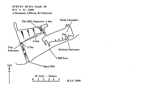
NOT OXENDALE WINDYPIT
Length: 15 m
Depth: 6 m
Grade: II
Entertainment value: II

Warning: Beware loose rock and broken glass in the entrance.

This rather short interesting hole is not easy to find: To the west of Oxendale Fissure lies a rubbish heap, 5 m beyond you come to an open fissure with a tree growing in the entrance. Follow this fissure until a rather grotty, unstable looking hole is found at the foot of a climb.

Drop down through the hole, Straight ahead is a short, flat out crawl under a poised boulder leading into a constricted boulder chamber with no way on. To the right one enters a low, roomy bedding type chamber with a
narrow rift along the south wall. Drop into the rift at the widest point and on into a small chamber. In the floor of the chamber is a very narrow rift. A tight squeeze down through the rift (larger cavers will experience major problems here, especially on the return) opens into a roomy chamber 4.5 m long and up to 7.5 m high. For those too fat to get back up the rift there is a rather sneaky back door: Climb up into the roof of the chamber at its highest point where a letterbox opens up onto the cliff face, an easy climb brings one back down to terra firma.

History
Discovered and dug by a joint S.C.C./ A.C.C. team between February and March 1999. The rather odd name resulted from heated discussions between two of the original explorers; one of whom wanted to call it Oxendale Windypit, the other didn’t. “Not Oxendale Windypit” emerged as something of a compromise!
mc=oxen

Newclose Rigg Pot (Stump Grinder Pot)

Moorland Caver (2003)

NGR:SE 869894
Altitude: 200m
Length: 15m
Depth: 20m
Access: Forestry Commission
Grade: I
Entertainment Value: II

Obvious fenced entrance around a loose body sized hole (might require some gardening).
Restricted (0.6m wide) pitch of 6m to a ledge at the top of a rubble cone is free climbable but is best hand lined or laddered (preferred) and belayed to a fence post.
NW the fissure tightens and ends but SE, the rift continues (although tight) and remains unexplored.

History
Discovered by forestry commission

Tackle
10m ladder and short belay

mc-stump

Nanny Coopers Hole

Moorland Caver (2003)

NGR: SE 553804
Altitude: 230m
Length: 6m
Access: Not known
Grade: I

On East side of Duckendale, in cliff face, 50m South of Duckendale Windypit.
Entrance is narrow fissure at right angles to cliff entering small chamber after short distance.

Lizard Rift

Moorland Caver (2003)

NGR:SE 708865
Altitude: 50m
Length: 45m
Depth: 20m
Access: Ravenswick Estate
Grade: II
Entertainment value: II

Warning Tread carefully, large numbers of small lizards have been found at the bottom of the entrance rift.

Hole is located a short way up the footpath leading off from the lane down to Yoadwath.
Oil drum entrance covered by a substantial slab (replace). The entrance drops directly into the top of a narrow rift the upper sections of which are somewhat loose (care).

The rift can be descended without tackle, however a handline (belay to nearby tree) is useful for the return. A landing is made at the intersection of rifts at right angles to each other. North was tight and blind but is now backfilled; heading South is impossibly tight and pinches up after 5m. East has a tight entrance into a widening rift that continues for 5m to a choke which hasn’t been pushed.
The way on is West, dropping through a very tight slot in the floor and descend into widening rift (circ 40cm) to extreme dodgyness. Crawl under boulder choke into area of hanging boulders and gravity defying rubble slope. A small excavated crawl in the choke underneath the rubble slope marks the present limit of exploration (16-1-97)

Tackle
Entrance: 8m handline (optional), belay to nearby tree.

History
Entrance opened during the construction of new track, explored by S.C.C. in 1996.

mc-lizard

Lizard Rift

Hole-in-the-Road Windypit

Moorland Caver (2003)

NGR: SE 496 894
Alt: 340m
Length: 6m
Depth: 8.6m
Access: Not Known

Entrance is located on a bend in a forestry track in Boltby Forest.
A body sized hole drops down a narrow rift ending in rubble blockage after 8.6m

History
Found in 2002 after a tractor wheel broke through the surface of the track.
The shock caused bad smells and stains in the trouser department.

mc-hole

Hayes Hole

Moorland Caver (2003)

NGR: SE 532819
Altitude: 200m
Length: 10m
Access: Forestry Commission
Grade: I
Entertainment value: I

Located on the left side of the track 100m down from the gate.
Small but strongly draughting body sized hole at track level heads into the hillside to a chamber formed in a cross rift. This is a badly broken down area and is the site of an active dig (beware).

History
In a letter to Roger Cooper, Raymond Hayes wrote “whilst walking with friends on the track out of Cockerdale, I passed a small, strongly draughting hole, on the right. Due to the company, I was unable to explore and continued walking with a mind to come back another day” Sadly, neither Roger nor Raymond ever did.
The hole has been named in honour of that pioneer windypit explorer: Raymond Hayes

Haggland Pot

Moorland Caver (2003)

NGR: SE 961923
Altitude: 150m
Length: 6m
Depth: 4.2m
Access: Duchy of Lancaster
Grade: I
Entertainment value: I

Small slip rift overlooking Lowdales valley.

A body sized hole drops into a 1m x 2.5m chamber. A steep slope continues down to the deepest point of the windypit, a whole 4.2 metres below surface. The rift narrows and ends in a blank wall.
mc-hagg

Eastfield Quarry Caves

Moorland Caver (2003)

NGR: TA 040847
Altitude: 50m
Length: Circa 30m (this is approximate)
Access: No known restrictions
Grade: I
Entertainment Value: II (If the local drug users are around)

Warning
Beware of drug paraphernalia and needles.

Drive along Eastfield high street and park up just beyond the shops.
To the left is a shallow valley with burnt out cars in the stream at the bottom.
Following the valley for 500m leads to a small quarry on the left with a limestone band and obvious cave entrances.

All entrances run parallel with the cliff face and exit or pinch up. A small passage continues into the hillside and emits a strong draught, (a dig here might surprise).

mc-east

Duckendale Windypit

Moorland Caver (2003)
NGR: SE 553805
Altitude: 230m
Length: 20m
Depth: 17m
Grade: II
Entertainment Value: II

Amongst dense vegetation and woodland, half way up rocky stepped slope on East side of valley. A tight rift drops round awkward corners into a blind chamber.

Tackle
20m ladder, stake and sling for belay. 20m lifeline.

History
Explored by M.S.G. in 1981