The geology of the North York Moors is dominated by rocks of the Jurassic period and is extremely varied. Most deposits were laid down under subtropical seas 205 to 142 million years ago. Fluctuations in sea level over this period produced many different rock types varying from shales to sandstones and ironstones to limestones derived from coral beds. These marine and delta deposited rocks are superbly exposed on the Yorkshire coast from Staithes to Filey.
 Refs for most images as I sent before or see GCR
http://www.thegcr.org.uk/ImageBank.cfm?v=21&Style=Chapter&Chapter=04
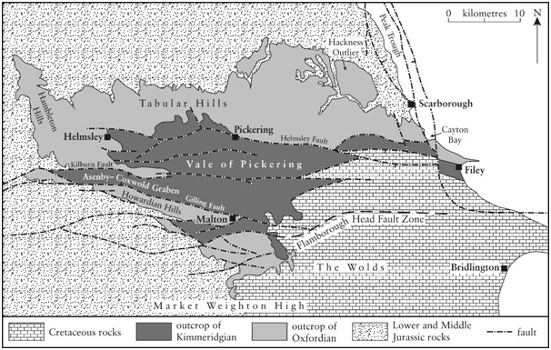
From a cavers point of view interests lie in the rocks of the Upper Jurassic 154 -159 MYA. Towards the end of this period the land sank beneath the sea. The sea in the locale was warm and shallow, subsequently a broad, shallow carbonate platform was established generating a series of calcareous sandstones and limestones. These rocks form the Corallian Oolitic Group (70-150m) running from the upper moorlands of the area and comprise the Tabular, Hambleton and Howardian hills.
During the Quaternary and over the last 2 million years, the area has experienced a sequence of glaciations. The most recent glaciation, the Devensian, ended somewhere around 11,000 years ago. The Jury still remains out as to the full extent of the ice sheets in this region of the country, however large glaciers formed and meltwaters flowed southwards on either side of the higher land mass, eventually forming a vast lake, now the Vale of Pickering. The waters from the lake flowed out to the west cutting a deep valley, Kirkam Gorge.
Unlike many other caving areas the North York Moors does not contain obvious surface features, there are few shakeholes, however the local quarries and numerous escarpments and cliff faces provide valuable sources of geological data.
From a stratigraphical top down approach there are remants of phreatic cave formation situated beneath the uppermost rocks. The Coral Rag member is circa 12m in depth, is highly fossiliferous and contains numerous bivalves, oysters such as Lopha, gastropods and echinoids Hemicidaris. This unit belongs to the Parandieri Subzone, and comprises coral–algal patch reefs, coral–shell inter-reef debris and micritic limestone. The most notable voids can be seen within Nunnington and Leysthorpe Quarries situated beneath comprehensive fossil beds.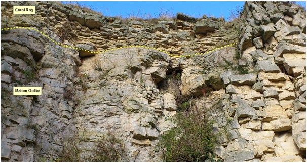
Leysthorpe Quarry (Photo Richard Edwards)
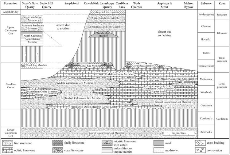
Kirkdale, Fadmoor, Manor Vale, T’une mouth/Youen Mouth and many of the caves which are fully or partially infilled with glacial debris reside within the Malton Oolite. The Member was previously refered to as the Osmington Oolite, it separates the Middle Calcareous Grit from the the higher Coral Rag Member, and comprises variably shelly, ooidal limestone. Quarries in and around Malton show large scale cross-beddings, indicating deposition from lateral migrating ooidal shoals, similar to those observed on Bahaman Banks today. This white to grey member extends as far south as the village of Langton, Malton and ranges to a maximum thickness of 40m. Bog hall rising is the only active cave known to exist within this member, however large springs resurge from within its beddings at numerous locations and it is suspected that other actives systems await discovery.
Bog Hall rising (Image:Petelovespurple@flickr)
The two main cave forming bands, the Malton and Hambleton Oolites are separated locally in many areas by the Middle Calcareous Grit, a sandy ooidal limestone which too forms caves, of which Dowson’s Pot is a fine example. The Grit outcrops in the south-east of the Hambleton Hills and upon Byland Moor where it reaches a thickness of around 12 m, a similar thickness is observed above the entrance of Excalibur Pot. It is similar in lithology to the Birdsall Calcareous Grit and is often decalcified where it outcrops, showing only relict ooids. The Grit thins across the Corallian series south towards Malton and east towards Scarborough, reducing to less than 2m at Spikers Hill Quarry, West Ayton.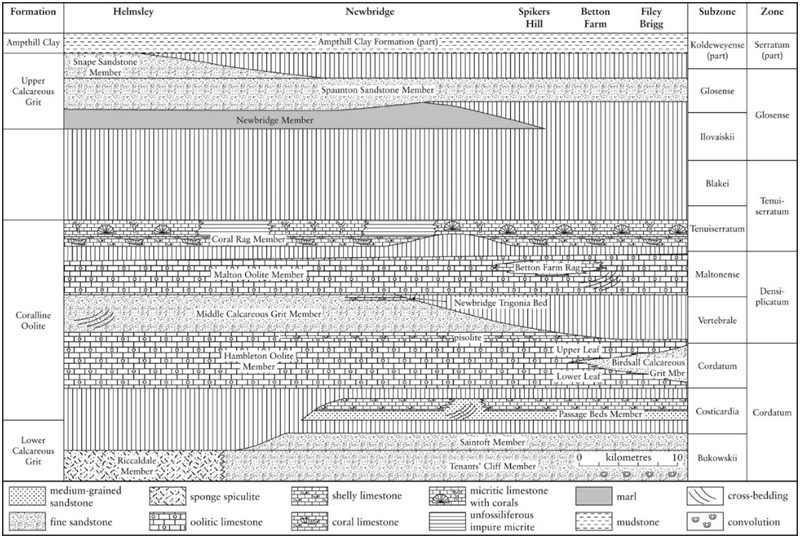
The Hambleton Oolite member circa 35m in thickness appears to date, to contain the most extensive cave systems in the area (Excalibur Pot/Jenga Pot), most of the windypits are also formed within this highly fractured/fissured limestone. The Hambleton tops the escarpment of the Hambleton Hills and forms extensive dip slopes north of Pickering. It consists of yellow weathering to pale grey /white ooidal limestone and contains a variable proportion of quartz sand, peloids and fragmented shells, chert nodules are also common in places. These cherts can be observed throughout the Excalibur/Jenga system and are striking in chert alley and towards chertnobyl. It appears that cave development may be driven at some points in the system via these chert bands. Sumps 1, 2 and 3, located to the southernmost extent of Jenga Pot are situated along the chert interface where it forms a virtually complete bed. Thin beds of calcareous sandstone with scattered ooids are present in the southern part of the outcrop. Cross-bedding and shallow scours are locally common in the ooidal limestone and the beds are frequently penetrated by circular, vertical burrows, up to 1 cm in diameter. The oolite member splits into an upper and lower leaf in parts of the Hambleton Hills and in the Howardian Hills. Ammonites indicate an age ranging from the Cordatum Subzone to the Vertebrale Subzone, spanning parts of the Cordatum and Densiplicatum zones.
Blake, J.F., Hudleston, W.H. 1877. On the Corallian rocks of England. Quarterly Journal of the Geological Society of London, 33, 260-405
Hudleston, W.H. 1878. The Yorkshire Oolites. Part 2, Section 2, The Coralline Oolites, Coral Rag and Supra-coralline Beds. Proceedings of the Geologists’ Association 5, 407-494
Martin-Garin, B., Lathuiliere, B., Geister, J. 2012. The shifting biogeography of reef corals during the Oxfordian (Late Jurassic). A climatic control? Palaeogeography, Palaeoclimatology, Palaeoecology 365-366, 136-153
Powell, J.H. 2010. Jurassic sedimentation in the Cleveland Basin: a review. Proceedings of the Yorkshire Geological Society 58, 21-72
Rawson, P.F., Wright, J.K. 2000. The Yorkshire Coast. Geologists’ Association Guide 34, 3rd Edition. 130p.
Wright, J.K. 1972. The Stratigraphy of the Yorkshire Corallian. Proceedings of the Yorkshire Geological Society 39 (2), 225-263
Wright, J.K. 2001a. Betton Farm. In: Wright, J.K. & Cox, B.M. British Upper Jurassic Stratigraphy (Oxfordian to Kimmeridgian). Geological Conservation Review Series No. 21, Joint Nature Conservation Committee, Peterborough, 94-96
Wright J.K. 2001b. Newbridge Quarry. In: Wright, J.K. & Cox, B.M. British Upper Jurassic Stratigraphy (Oxfordian to Kimmeridgian). Geological Conservation Review Series No. 21, Joint Nature Conservation Committee, Peterborough, 157-161
Wright, J.K., Rawson, P.F. In press. The development of the Betton Farm Coral Bed within the Malton Oolite Member (Upper Jurassic, Middle Oxfordian Stage) of the Scarborough District, North Yorkshire, UK. Proceedings of the Yorkshire Geological Society