Moorland Caver (2003)
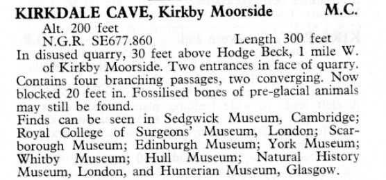
NGR: SE 678857
Altitude:58m
Access: No known restrictions
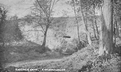
Caves lie in an abandoned and overgrown quarry to the NW of the (often dry) ford over Hodge Beck.
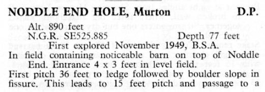
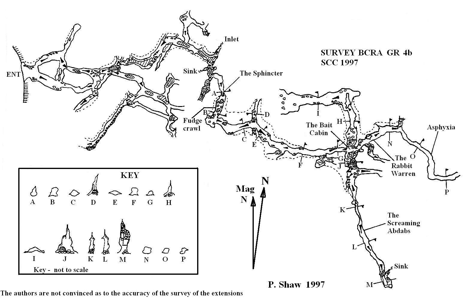
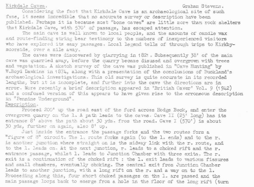
KIRKDALE I
Length: 436m
Grade: III
Entertainment value: II+ (masochists excepted)
Warning: Beware of foul air in Asphyxia.
Kirkdale I can effectively be divided into two parts: The old cave known from 1821 onwards and the extensions as discovered and dug by S.C.C. in 1995/6. The old cave is a pleasant, if somewhat tame, outing and is well suited for novices and their instructors who seem to be the main users of the cave. The extensions, in contrast, are low, squalid and gloopy, however they seem to offer a strange fascination to a small number of diggers, perhaps hunting for the fabled link with Manor Vale Caves.
“The Old Cave”
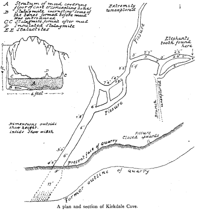
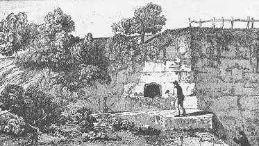
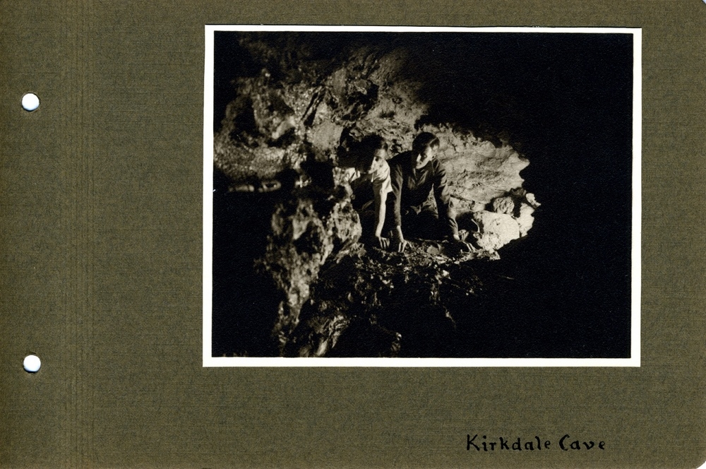
The obvious entrance lies 2.5m up the quarry face and is reached by an easy climb. Once inside the passage divides almost immediately, either route leading into the further ramifications of the hole. About 10m in a cross rift links both the left and right hand routes. The right hand route continues past the cross rift and soon reaches a T junction: The passage to the right chokes, whilst that to the left reaches Junction Chamber. The left hand route also continues past the cross rift and combines with the right hand route at Junction Chamber. In essence Junction Chamber is a crossroads with two routes leading deeper into the cave. The left hand exit from Junction Chamber leads to a further junction with ways on to the left and right, which reunite, forming a loop. The right hand exit from Junction Chamber is the key to the cave leading as it does to the extensions. This stooping/crawling passage can be followed around a couple of corners until it ends in a choke; this is the end of the old cave.
N.B Northern Caves notes that “one passage ….. leads to a sump, dived for 9m to 45m of muddy passage which becomes too tight”. Divers looking for this sump will be disappointed – it does not exist!
The extensions
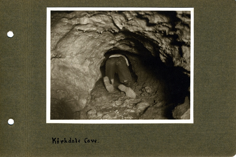
About 8m back from the end of the old cave lies a muddy passage heading east. The extensions are entered via a low wet section known as The Sphincter (flat out, ear in water). On the way in this is unpleasant, however the return trip is more interesting; a slope at the end of the pool plunges one head first into the water. The Sphincter, leads to Fudge Crawl, which as the name suggests is extremely muddy. Progress here is flat out crawling in very tenacious mud, the only relief being a small chamber formed on a cross joint where it is just about possible to sit up. More flat out crawling in porridge brings one to the Bait Cabin. The Bait Cabin, formed on a further cross joint, is a reasonably sized chamber (by Kirkdale standards) and contains some reasonable formations. The cross joint can be followed in two directions: To the North soon becomes too low and is being used as a dump for dig spoil, whilst to the south, the Screaming Abdabs, is tight and awkward. Two further passages leave the Bait Cabin: The one nearest to the Screaming Abdabs known as The Garage ends blind after a few metres. This leaves the continuation of the “main passage” appropriately called Asphyxia. Asphyxia is a flat out crawl, passing a couple of squeezes and ending in an active dig. Air circulation at the dig is poor, high concentrations of Carbon Dioxide build up in a short space of time. Returning from the dig is complicated by the lack of turning room, the passage has to be negotiated feet first, backwards.
History
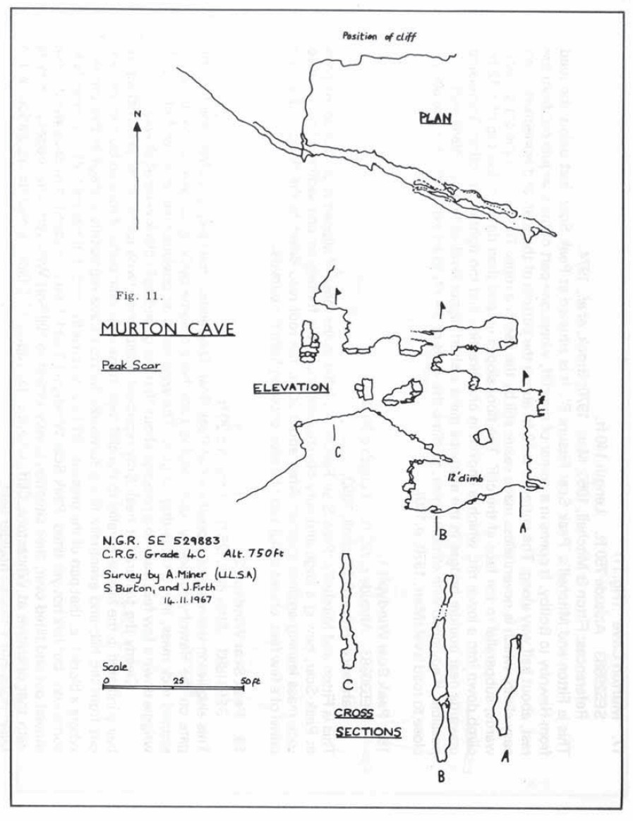
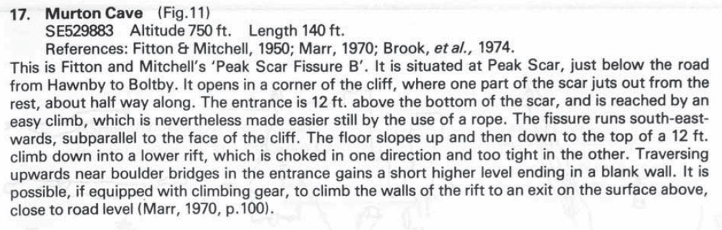
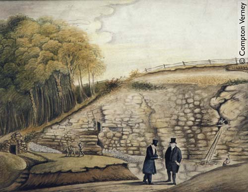
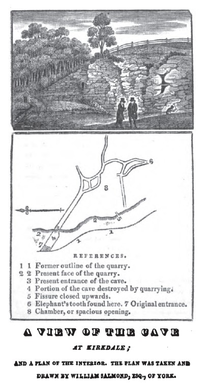
During the summer of 1821, as a result of quarrying operations, quarrymen “accidentally intersected the mouth of a long hole or cavern, closed externally with rubbish and overgrown with grass and bushes” . Initially the entrance to the cave was very small, however continuing operations in the quarry removed somewhere in the region of 30 ft of passage leaving the rather more impressive entrance that we know today.
When the quarrymen first broke into the cave they were not aware of the significance of the numerous bones that they were finding, supposing them to have belonged to cattle that had died by a “murrain” in the area a few years previously. As a result the bones were used, along with the quarried limestone, for road repairs in the district. However it was not long before the significance of the find was recognised. The credit for this goes not to Buckland as popular myth would suggest, but to a Mr Harrison “a medical gentleman of Kirbymoorside”. News of the discovery spread and various gentlemen including Mr. J.Gibson of Stratford in Essex, Rev. Smith of Kirbymoorside and Mr W.Salmond of York explored the cave and in the process removed numerous bones. Amongst others interested in the find was the Bishop of Oxford and it is to him that credit must go for bringing Kirkdale to the attention of Buckland.
As far as can be ascertained Buckland started work at Kirkdale in 1821. During his visits (1821 & 1822) to Kirkdale. Buckland enumerated the remains of 23 species of animals from which he concluded that Kirkdale had been hyena den.
Since Bucklands excavations little serious work was done in Kirkdale until recently, the cave becoming something of a local curiosity. As with many well known caves Kirkdale has attracted its own share of myth, most notably the fabled connection with Manor Vale Caves (q.v) at Kirbymoorside. The oft-repeated story tells of a chicken, which entered Kirkdale, did the through trip and exited at Manor Vale with less than its usual complement of feathers!
SCC began work in Kirkdale in late 1995. A protracted dig pioneered a route past the “Sphincter”. From the breakthrough the S.C.C. explored a new series of passages, which increased the length of the known cave by 260m making Kirkdale by far the longest cave in the district. Asphyxia is currently being dug on an intermittent basis.
KIRKDALE II
Length: 8m
Grade: I
Entertainment value: I
Entrance lies 30m south of Kirkdale I (q.v). The cave is an uninteresting single passage, which soon chokes.

Pennine Underground (1965)
Northern Caves Volume 5 (1974)
BCRA Transactions – Vol.3 No.2 – The North Yorkshire Windypits (1976)
Moldywarps Speleological Group – Journal 6 (1973)
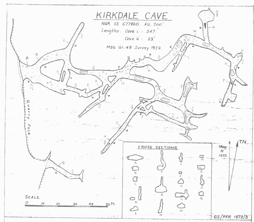
SCC Survey (1997)