BCRA Transactions – Vol.3 No.2 – The North Yorkshire Windypits (1976)
Category Archives: Cave
Kirkdale Howl
BCRA Transactions – Vol.3 No.2 – The North Yorkshire Windypits (1976)
Peak Scar Windypit
Moorland Caver (2003)
Alt: 230m
Access: No known restrictions
Peak Scar represents some of North Yorkshire’s finest climbs, its honey coloured rock is both strong and grippy. The weathered limestone cliff has all the good plus points for climbing. It is almost on the side of the road, it’s easily roped and has an abundance of good handholds. On a mild summers evening with a warm orange sun lighting up the cliff you have to ask your self “where else would I rather be? “. Why, Under ground of course!!
Peak Scar has three known caves and a myriad of little crawls amongst jumbled blocks, the caves aren’t particular big but when the warm orange sun is setting, what else is there to do. Go on, do some exploring then go to the pub.
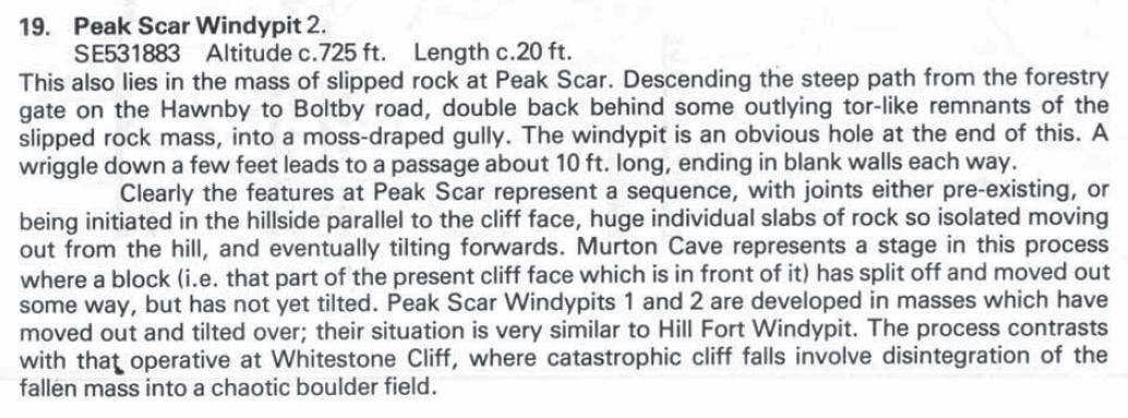
PEAK SCAR WINDYPIT 1.
NGR: SE 530883
Length: 10m
This doesn’t fit in the term of windypit, as it is merely a slumped slab rock with a void underneath. However it does deserve a mention. It lies in a mass of fallen blocks beside the path, the entrance is quite large and rift like, continuing for 6m and ending after a short crawl where day light can be seen.
PEAK SCAR WINDYPIT 2.
NGR: SE 531883
Length: 7m
This is also amongst slumped blocks, beside the path. Doubling back into damp fern strewn gully to entrance at end. Squeeze down into small rift ending in blank walls.
BCRA Transactions – Vol.3 No.2 – The North Yorkshire Windypits (1976)

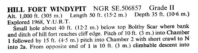
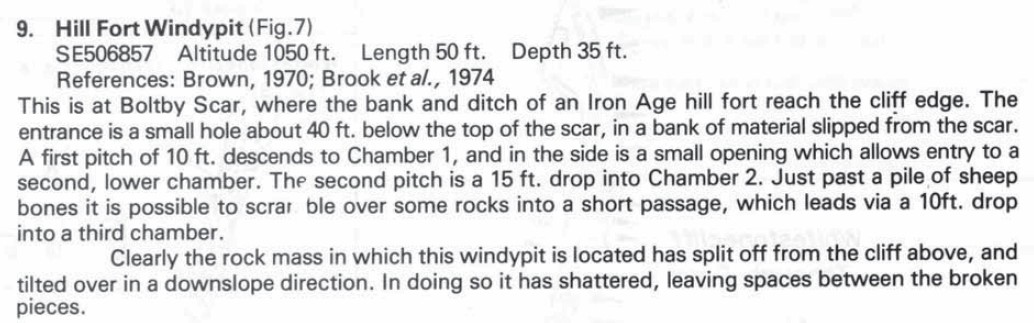
Hill Fort Windypit
Moorland Caver (2003)
NGR: SE 505867
Altitude: 320m
Length:15m
Depth:11m
Access: No known restrictions
Grade: II
Entertainment Value: I
Entrance is a small hole about 12m down from Boulby scar, in top of slumped bank. Vegetation completely obscures the entrance for most of the year, making it extremely difficult to find.
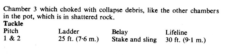
Entrance pitch of 3m, best laddered from tree, lands in Chamber 1 followed by 4.5m pitch into chamber 2 and 2a. From the opposite end of chamber 1 is a 3m climbable route into chamber 3. All chambers are in a jumble of collapsed blocks and are best laddered as one due to the loose nature of the walls.
Tackle:
8m ladder, 4m belay, 15m lifeline.
History
Explored by Y.U.R.T. in 1968 and called Hillfort after the assumed Iron Age Hill Fort on the bank top. The ramp and ditch features of the Hill Fort were later found to be slump features associated with slope failure.

Northern Caves Volume 5 (1974)
BCRA Transactions – Vol.3 No.2 – The North Yorkshire Windypits (1976)

Great Relief Pot
Moorland Caver (2003)
NGR:SE 511833
Altitude:300 m
Length: 3.6 m
Depth:3 m
Access: No known restrictions
Grade: I
Entertainment Value: I
From the public footpath at the at the top of the escarpment take the nature trail heading diagonally down slope. The entrance lies directly beside the path.
A very narrow fissure leads to an even narrower cross rift. What is interesting is the impressive draught that this hole produces – digging might pay dividends.
History
Discovered by A.C.V.S.U. in 1972.
Northern Caves Volume 5 (1974)

BCRA Transactions – Vol.3 No.2 – The North Yorkshire Windypits (1976)

Gowerdale Windypits (Windypit IV / Windypit V)
Moorland Caver (2003)
Until recently the Gowerdale Windypits had been used for the dumping of “farm waste”, rendering descents particularly unpleasant. However thanks to the good offices of Pete Roe and funding from English Nature the holes have now been cleaned up; let’s hope they stay that way! Nice one Pete.
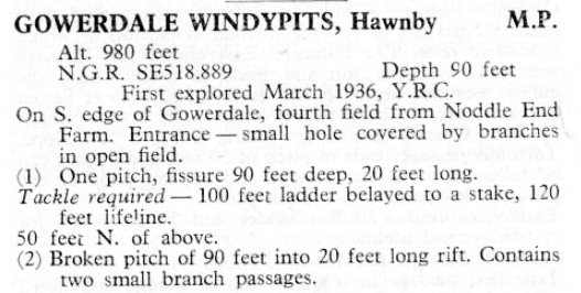
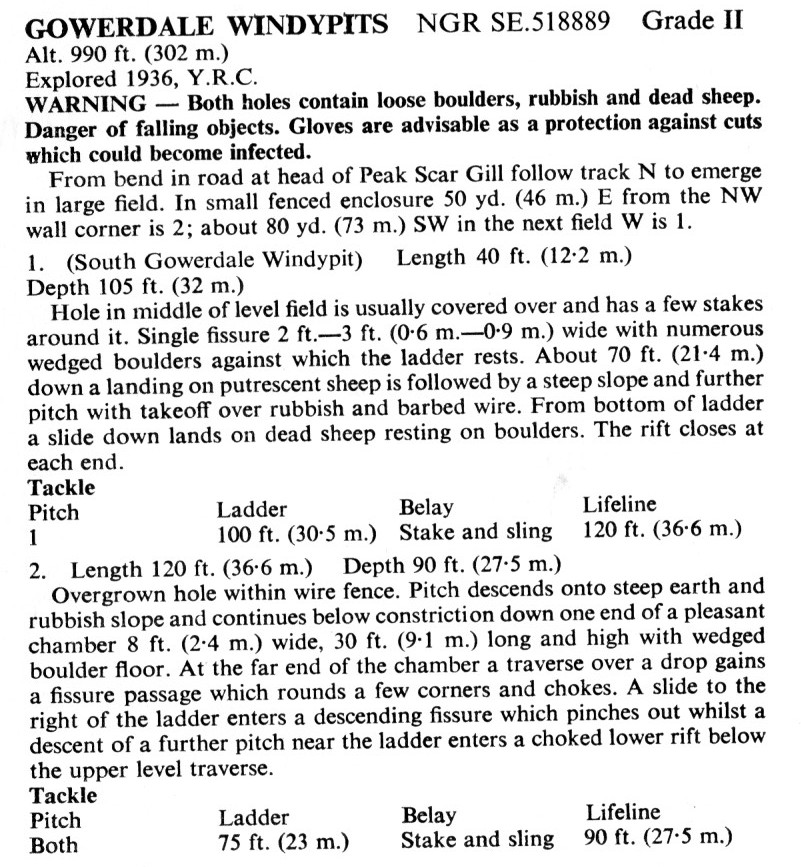
GOWERDALE I
(A.k.a Windypit V, South Gowerdale Windypit)
NGR:SE 517889
Length: 12m
Depth: 33m
Alt: 302m
Access: Permission to descend is not granted
Grade: II+
Entertainment value: I
The fissure, usually covered with timbers (replace), lies in a patch of uncultivated ground to the east of the field. Gowerdale I consists of a simple, albeit deep, single fissure. An absence of suitable belays makes a descent a problem; one solution is to lay a stout pole across the entrance. A descent of about 22m (with ladder resting on various chock stones) leads to a landing on rubble, followed by a second 6m pitch (ladder belayed to first) down to the bottom of the fissure.
Those who have bothered to come this far will be disappointed to find the fissure is blind.
Tackle
30m ladder, possibly belayed to a sturdy pole across the entrance, alternatively stake & sling.
History
Gowerdale 1 was discovered and descended in March 1936 by the Y.R.C. who named the hole Windypit V.
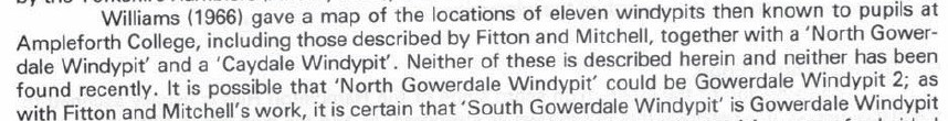
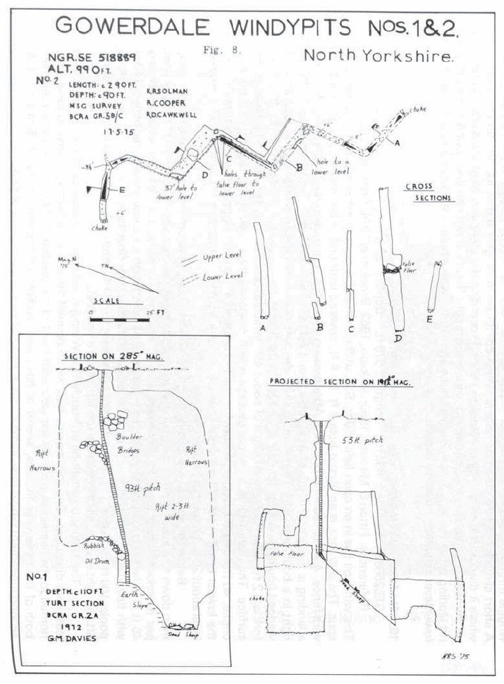
GOWERDALE II
(A.k.a Windypit IV)
NGR:SE 518889
Length: Circa 95m
Depth: 27m
Alt:302m
Access: Permission to descend is not granted
Grade : II
Entertainment value: ?
Gowerdale II lies in the next field east of Gowerdale I. The hole will be found at the north western corner of the field, surrounded by a wire fence. Belay ladder to tree on northern side of the fence. A descent of 6m lands on a rather unpleasant “rubble” floor. (3m down the pitch is a small eye-hole giving access to an 8m long fissure with a false floor). The way on is through a constriction in the floor. When visited by the authors in 1999 the constriction was blocked by a very offensive choke of bagged animal remains. At the time no one had the inclination (or strong enough stomach) to dig their way through, so the following description, in lieu of a more contemporary one, has been taken from Cooper et al (1976):
“The open entrance hole descends to an earth and rubbish slope ending at a small hole about 20′ down. The ladder must be fed through this hole.
The pitch then continues down one end of a chamber 8′ wide, 30′ high and 30′ long, with light coloured walls decorated by small calcite flows. A landing is reached after 53′.
To the right of the ladder a descending fissure floored with mud can be followed to a zigzagging lower passage with three sharp bends roughly equidistant from one another. The passage ends in a choke. Back at the bottom of the pitch, holes in the floor lead into a lower chamber beneath, showing that the main chamber floor is formed of wedged blocks. The lower passage ends in blank walls. At the western end of the main chamber a traverse past a hole leads round a bend and through a short crawl to a fissure passage which passes over a 3 1/2′ step down, to a 6′ upwards slope, and then chokes.”
Tackle
Northern Caves (Brook et al, 1988) recommends:
“25m ladder, stake and sling belay, 30m lifeline”; however a more suitable solution would be to belay to a tree circa 6m away.
History
Gowerdale II was discovered and explored in April 1936 by the Y.R.C. who named the hole Windypit IV.
The 8m fissure 3m down the pitch was dug into by Rick Stewart in 1999.

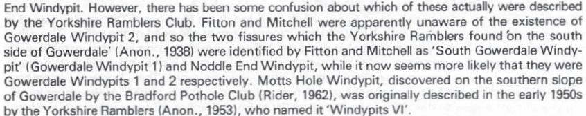
Yorkshire Ramblers Club – Journal 7 (1938)
North Riding, Hawnby, Windypits IV and V. (alt. 970 ft., S. edge of Gowerdale. Leave car E. of Silver Hills Farm, I mile from Boltby Bank, and go N. Leave must be obtained to remove the substantial coverings).—No. IV, April, 1936, H. L. and F. W. Stembridge and E. E. Roberts. 85 feet of ladder with a landing on the roof of the lower storey at 60 feet. Zigzag rift with three right angle corners, body width. Total depth 95 ft.
Pennine Underground (1965)
Moldywarps Speleological Group – Journal 6 (1973)

Northern Caves Volume 5 (1974)
BCRA Transactions – Vol.3 No.2 – The North Yorkshire Windypits (1976)


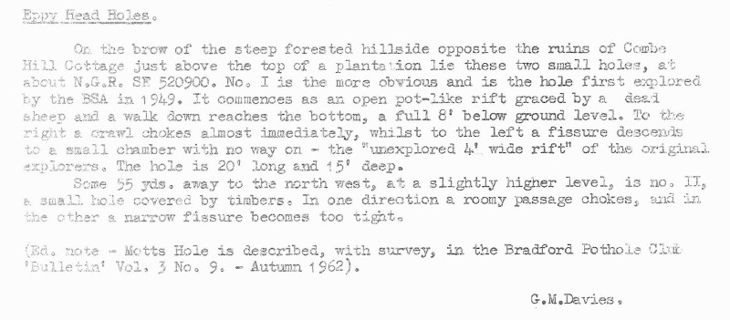
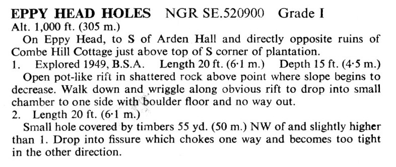
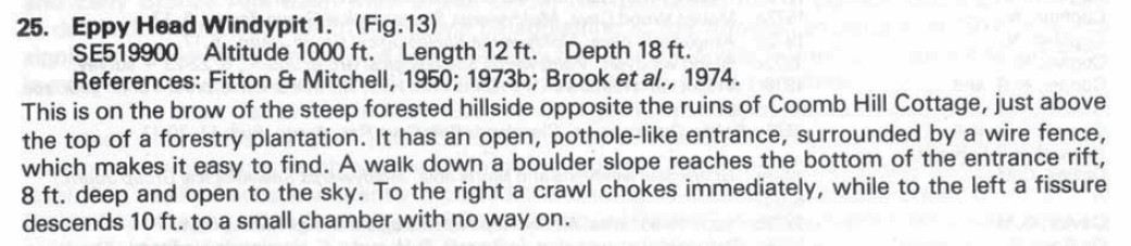
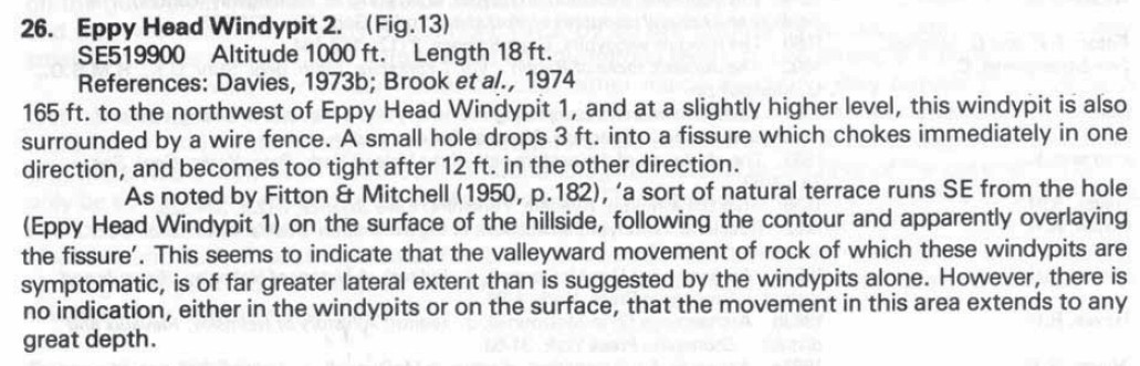
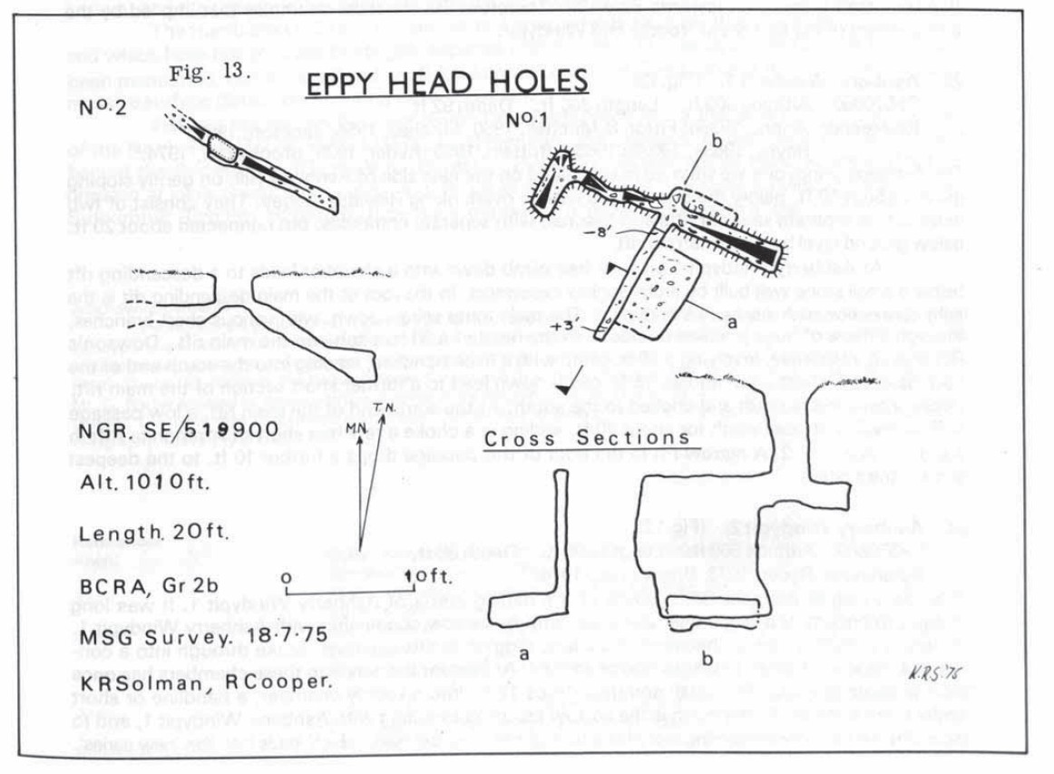
Eppy Head Holes
Moorland Caver (2003)
NGR: SE 520900
Altitude: 330m
Access: No known restrictions
Grade: I
Entertainment value: I-
View: V
Two small and uninspiring holes in the middle of nowhere, the only thing, which justifies the walk, are the wonderful views. Both holes lie on the break of slope on the spur between Spring Wood and North Wood.
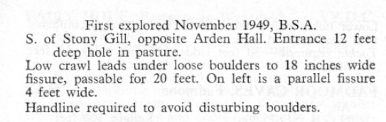
EPPY HEAD I
Length: 4.5m
Depth: 6m
2.5m deep entrance “shaft” is easily negotiated without tackle.
A narrow fissure leads to a blind chamber.
The entrance is currently (2000) blocked.
History Explored by B.S.A. 1949.
EPPY HEAD II
Length: 6m
50m to the north west of I. Small hole covered by timbers (replace). Short single fissure which chokes to the east and becomes too tight to the west.
History
Discovered by M.S.G. in circa 1975.

Yorkshire Ramblers Club – Journal 7 (1952)
Eppy Head, a large and dangerous opening at 1,000 ft. contour, S. of Arden Hall, Hawnby. The last is more solid than it seems, not deep, and can be climbed. Scovell, Simons, Parker and Roberts have done it
Pennine Underground (1965)
Moldywarps Speleological Group – Journal 6 (1973)
Northern Caves Volume 5 (1974)
BCRA Transactions – Vol.3 No.2 – The North Yorkshire Windypits (1976)
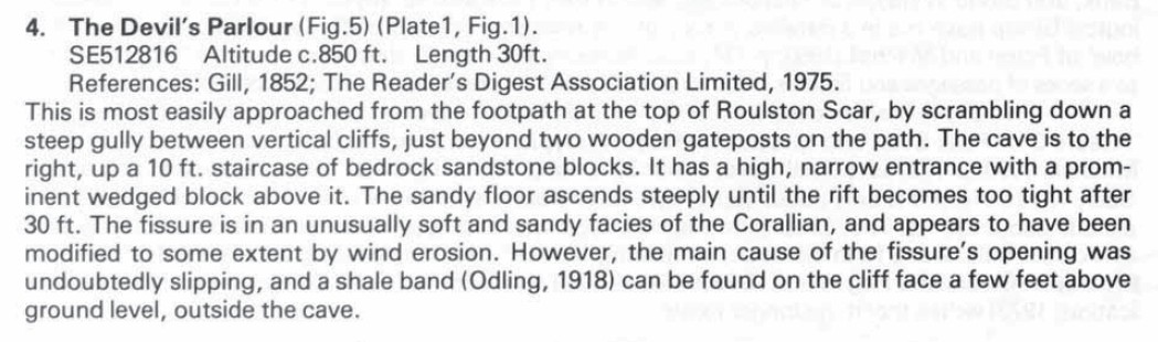
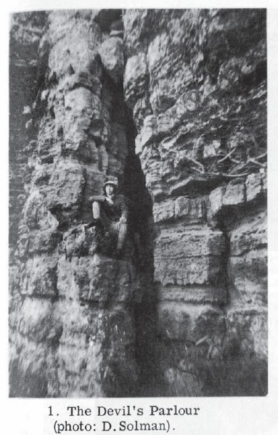
Devils Parlour
Moorland Caver (2003)
NGR: SE 512816
Altitude: 250m
Length: 9m
Access: No known restrictions.
Grade: I
Entertainment Value: I
The rift is located in Roulston Scar. From the footpath locate two wooden gateposts, just beyond is a steep gully between cliffs. From the bottom of the gully climb up a “staircase” of boulders leading to the entrance. The rift ascends steeply for about 9 m before becoming too tight.
History
Known since the 1850s, noted by the M.S.G. circ. 1974
BCRA Transactions – Vol.3 No.2 – The North Yorkshire Windypits (1976)

Hobthrush Hole
Moorland Caver (2003)
NGR:SE 450934
Altitude: 180m
Length: 4.5 m
Access: No known restrictions
Grade: I
Entertainment value: I
This “rock shelter” lies to the North West of Over Silton and is found about 3 m up a slipped section of cliff. The entrance is 1.5 m high x 1.2 m wide. The hole is about 2 m wide with two small avens at the far end. Also at the far end is a too tight tube estimated to be about 3 m long.
History
Cooper noted in MSG 7 that “Mrs Craik’s account of North Riding Folklore talks of a cavern (windypit?) N.W of Over Silton”. Hobthrush Hole was discovered by the M.S.G. in circa 1975; possibly the cavern referred to by Mrs Craik (?).
BCRA Transactions – Vol.3 No.2 – The North Yorkshire Windypits (1976)
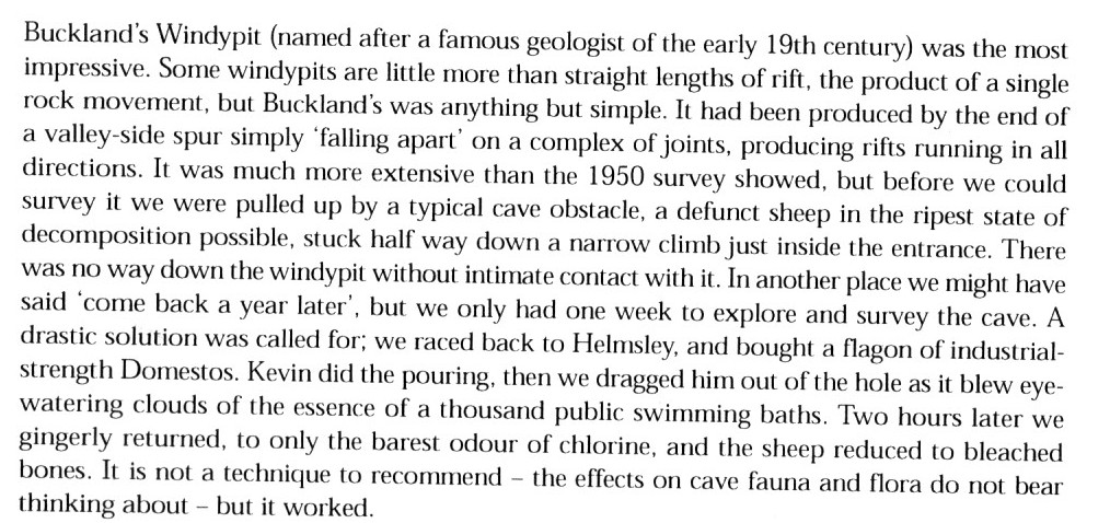
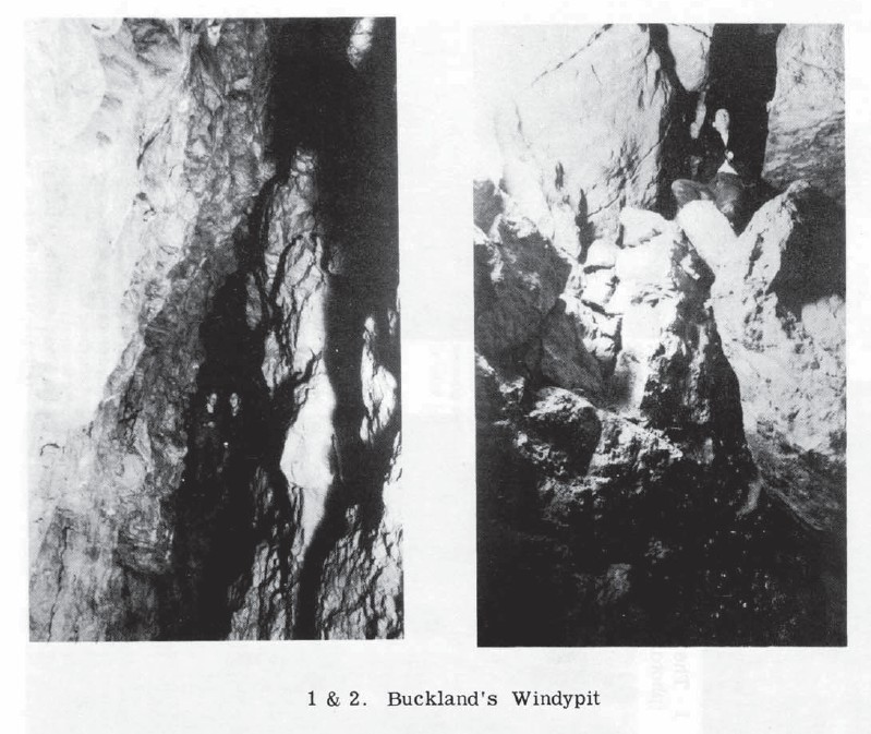
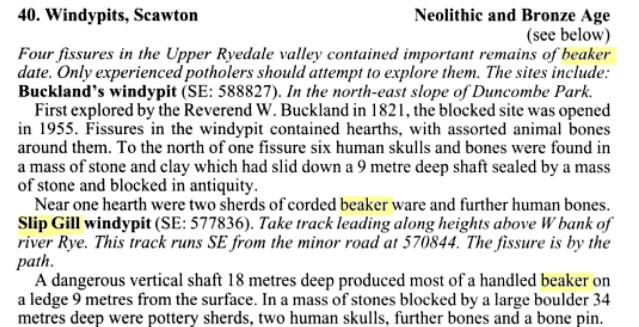
Bucklands Windypit (Helmsley Windypit / Windypit I / Deer Park Windypit)
Moorland Caver (2003)
NGR: SE 587828
Altitude: 130m
Length: 375m
Depth: 38m
Access: Permission to descend is not ordinarily granted. If you have a particular interest or reason for visiting, please contact us and we will see if we can help.
Grade: III
Entertainment value: IV
Located beside forestry track on edge of mature conifer plantation. Entrance is a large fissure, however a fallen tree disguises the fact and creates two entrances: North Entrance and South Shaft (a.k.a Holly Bush Pitch). North Entrance is a descending traverse (Lifeline / handline useful). Drop down through small entrance hole onto a ledge with an 8 bolt traverse and a chain in-situ (the chain was installed during the 1950’s and its use is not recommended. The bolts were installed in 2003). Traversing obliquely along ledges and boulders brings one to the foot of South Shaft. South shaft is a 9 m ladder pitch. South from the foot of the ladder is a short crawl which leads to the head of an 18 m pitch landing in Fissure S.
Loose rock abounds on the pitch and it is best avoided, given that it is easily by-passable.
The main way on lies at the North end of the entrance chamber. Negotiate a 2 m overhang to land on a ledge followed by a climb down the left hand side of the climb dropping into the Main Fissure (stony corridor). The foot of the climb is a junction.
Chamber / Fissure R: Looking down the Main Fissure a branch fissure leads off to the left into a small chamber known as Chamber R. At the far side of Chamber R is a small fissure (Fissure R) at floor level. An oblique descent of Fissure R back under Chamber R brings one to a small chamber.
Fissures S, T, U: Back at the Junction; to the left of Chamber R is a short crawl leading to a rubble slope at the head of Fissure S. Two cross rifts lead off from Fissure S: Fissure U to the right and Fissure T to the left.
This series of fissures was very productive in terms of archaeological material; any bones etc found in the vicinity should be left undisturbed.
Fissure J: Descend the Main Fissure (Stony Corridor) to a large boulder chamber. At the foot of the climb down into the chamber a hole will be noticed on the right, which descends down to a choke. It is possible to traverse up and over the choke to a point where the fissure becomes too tight. The M.S.G. established a vocal connection between this point and Fissure T.
Oxtail Chamber & the F series: Back at the chamber; a climb up behind a large boulder gives access to a large chamber known as Oxtail Chamber. Oxtail Chamber is an important junction leading to the F series fissures. Fissure F1 (Dead Man’s Gulch) lies at the far side of the chamber and is reached by various routes up, under, over and round boulders. Traverse out over 10 m drop on ledges to chock stone, from here a series of traverses and descents bring one to the deepest point. Fissure F2 is a narrow (and rather pointless) descent of about 6 m (ladder useful); becomes too tight. Fissure F3 is located to the left of F1 and ends after 10 m in a rather unstable boulder choke. To the right of F3 lies Fissure F4, the key to the extensive “New Series”. The obvious way into F4 is to chimney down into the fissure and negotiate a rather awkward squeeze, beyond the squeeze the fissure chokes after about 7 m. However if one traverses over the drop a route can be followed over the choke into Hayes Hall
The New Series: Hayes Hall is a large chamber at the junction of several fissures, which comprise The New Series. various small, choked fissures lead off from the South end of the chamber. The main “New Series Fissure” is an impressive piece of passage running North East from Hayes Hall. This fissure is somewhere in the region of 40 m long and terminates in a large choke known as the Great Stone Slide which is believed to come quite close to the surface. Two branch fissures lead of from the Main Fissure. The most obvious lies on the left (looking up from Hayes Hall) and is entered via a 4 m climb down. The fissure terminates in the inevitable boulder choke after 10 m. Back at the junction a second branch fissure leads of on the right.
Tackle
North Entrance: 5m handline
8 bolt Traverse: 20m handline
South Shaft: 9m ladder, nearest belay point circa 5 m away (tree)
Fissure S Pitch: 20m ladder, possible to belay to boulder in crawl.
Fissure F2: 6m ladder.
N.B. it is possible to make a full descent without any tackle.
History
First, partial, descent by Dean Wm. Buckland in July 1822. Buckland produced the first written description of the descent of a Windypit. Visited and bottomed by W.V. Brown and E.E.Roberts of the Y.R.C. in May 1935 who named the hole Windypit I. During WW2 various servicemen stationed locally descended including one Chadwick (A Y.R.C. member named Chadwick discovered Windypit VI / Motts Hole (q.v) in 1947). This period also saw a visit by Raymond Hayes and Peter Precious. Paul Fitton & Doreen Mitchell of the B.S.A. examined the hole in 1949 as part of their work on the Ryedale Windypits, during which they produced the first known survey of Bucklands Deer Park Windypit (as they called it). In 1954 a group of local archaeologists under the leadership of Raymond Hayes began work in Bucklands. 1954 saw the discovery of Fissures S, T and U by one of Hayes’ team; David Lamplough. The same year also saw Hayes, J.F.A Smailes and C. Brewer discovering the extensive New Series. The M.S.G. looked at Bucklands in 1981 and produced the “definitive” survey. Recent extensions were made in January 1998 by R. Stewart and A. Bolton who managed to descend Fissure R and later in the same year S.C.C. extended the unnamed fissure on the left of the great stone slide.

Buckland – Reliquiae Diluvianae (1823)


Yorkshire Ramblers Club – Journal 6 (1935)
Helmsley (Yorkshire), Duncombe Park, Windy pits (in the deer park, 430 yards from the footbridge, bearing 195° or 15″ west of south, marked by a great sawn-off tree trunk). — May, 1935. W. V. Brown and E. E. Roberts. The opening is. well known to local people, and several descents have been made to about 90 ft. A straight and narrow fissure, evidently unexplored, was found above two big boulders, and descended from chockstone to chockstone for 80 ft., aided once by the wire ladder. Total depth, about 150 ft. Other minor fissures were explored. Leave should not be difficult to obtain but the shooting months should be ascertained.
BCRA Cave Science – Vol.2 No.12 – The Ryedale Windypits (1950)

Pennine Underground (1965)


Northern Caves Volume 5 – (1974)

BCRA Transactions – Vol.3 No.2 – The North Yorkshire Windypits (1976)


BCRA Cave Science – Vol.9 No.1 – The Windypits in Duncombe Park (1982)


Discovering Prehistoric England (2001)
Life and Death in the Ryedale Windypits Near Helmsley, North Yorkshire
Stephany Leach, University of Winchester,
Bucklands Windypit is the most southerly of this group and although it consists of quite an extensive series of fissures and chambers, archaeological material was only recovered from fissure S, a U-shaped fissure with two small adjoining chambers. Prehistoric Beaker pottery sherds, evidence of hearths, a flint tool and animal bones including auroch were recovered from the base of fissure S. The presence of this material leads to the belief that the human remains discovered in this fissure were ‘Beaker burials’. Several human skulls together with bones from other parts of the body were excavated from the base of a steep muddy slope. These skulls were interesting for two reasons, firstly they exhibited evidence of blunt force injury, some with multiple injuries (Figs 2a and 2b) and secondly, the radiocarbon dates show these individuals were deposited in this cave during the 2nd Century AD

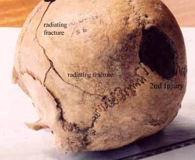
Figs 2a, 2b: Skull from Bucklands exhibiting evidence of two blunt force injuries with radiating fractures
Evidence of an attack with a blunt weapon is quite rare in the skeletal record during the Romano-British period; trauma from bladed weapons is far more common. The attack on these people from Bucklands was brutal, lethal and contained a definite element of overkill. Who were they and why were they treated so violently? The skeletal report compiled in the 1950s stated that no trauma was present in the bones excavated from Bucklands, Slip Gill and Antofts. However, advances in forensic science have proved invaluable for the interpretation of fractures and cuts present on human remains from archaeological contexts.
The noted elevated prevalence of trauma in material from cave sites may suggest that their use was associated with times of social upheaval, a link between people being placed in caves and ruptures in the fabric of society. Did they consider the caves and fissures as special places, part of the sacred natural landscape, a place perhaps to commune with ‘otherworldly’ beings? Alternatively, they may have been seen as dark, dangerous but perhaps convenient locations for what might be considered deviant burials. There must have been some degree of difficulty involved in transporting a corpse into the lower chambers of these fissures, unless the bodies were simply tossed over the edge, as would appear likely in the case of Slip Gill Windypit. These fissures were not simply the easiest option for mortuary disposal; furthermore the entrances to the Windypits are not obvious or prominent features in the landscape.
The Ryedale Windypits were not simply repositories for Beaker burials. It would appear that certain caves were repeatedly used during a considerable period of time, approximately 2000 years, while other fissures were ignored. We can also see evidence for a continuation of prehistoric mortuary activities at these sites well into the Romano-British period, the archaeological evidence indicating differential yet contemporary use of the subterranean realms during the 2nd Century AD. In conclusion, by liberating the skeletal evidence from our preconceptions and allowing the bones to tell their own story, we have gained unique insight into the life and ultimate demise of the people of the Ryedale Windypits.
Memoirs of a Moldywarp (2008)