All posts by chris.twigg

Sutherbruff Rigg

Moorland Caver (2003)

NGR: SE 860867
Altitude: 155m
Depth: 18m
Access: Forestry Commission
Grade: I
Entertainment Value: II

Located in woods near forest track, entrance is 2m x 0.5m slot with fence around. Climb down 3m into narrowing rift which drops steeply to a “T” junction, soon after all passages become too tight

History
Explored by B.A.C.C. in 1972

Northern Caves Volume 5 (1974)
nc-suther

Spaunton Cave

Moorland Caver (2003)
Altitude: 130m
Length: Circa 21 m
Access: Recent attempts to regain access to this cave have not proved successful. Please do not approach the farmer on whose land the cave lies as this could compromise any future access.

The cave was explored and described by Paul Fitton in 1948/9. As this cave has not been accessible or, indeed, open since the late 1940s (when the entrance was back-filled) it is worthwhile to record Fittons description in full:
“The entrance shaft descends through 6 feet of loose earth and gives the impression that it is party (sic) of a much larger rocky opening which has become completely blocked by soil. The floor is composed of sandy clay, which has evidently run in from the entrance, and a certain amount of excavation was necessary before the original explorers could follow the passage. The roof is a flat bed of limestone and shows little trace of water action. The cave comes to an end in a constricted passage, which is completely blocked by a fall of roof.
It seems possible that excavation might reveal a continuation of the passage on the opposite side of the entrance shaft.
The cave is very reminiscent of Kirkdale, Fadmoor and other caves in the area …”

History
Entrance collapsed under the weight of a farm trailer in September 1948. The cave was explored and surveyed on 7.11.1948 by R. Hayes, J. Bridge and E.P Fitton.

Sinnington Caves

Moorland Caver (2003)

NGR: SE 744867
Altitude: 60m
Length: 5m
Access: No known restrictions
Grade: I
Entertainment Value: I

Caution, Cave 2. has been frequented by Foxes.

From Sinnington village keep to the right of the river Seven until an open field is reached. The caves lie in cliff under Hunter Hill.
The two short uninspiring caves end in small fissures after 5m and have no obvious ways on.

mc-sin

Shaws Gill Hole / Shaws Gill Rift

Moorland Caver (2003)

NGR: SE 531818
Altitude:200m
Depth: 8m
Access: Forestry Commission
Grade: II
Entertainment Value: I

Small hole in depression on the right of the track 200m down from the gate. Drops down and squeezes back under entrance. Sharp right turn (best negotiated head first) slides into lower chamber with vocal link to the surface on the right. The way on is a draughting rift under two jammed boulders on the left but there isn’t an easy way to break through as the two boulders support some of the roof slabs.

History
Found by S.C.C./M.S.G. in April 2003 whilst looking for Hayes Hole

SHAW’S GILL RIFT

NGR: SE 532819
Altitude:220m
Length: 4m
Access: No known restrictions
Grade: I
Entertainment value: II

Small rift entrance in a small cliff on right side of track 100m down from the gate, almost opposite Hayes hole. A nice sized entrance degenerates into a very small rift turning acute right after only 1.5m and ending in boulder ruckle 2m after the turn.
If your chest is bigger than 17cm then this isn’t for you.

History
Found by S.C.C./M.S.G. in April 2003 whilst looking for Hayes Hole.

Scarborough Castle Rift

Moorland Caver (2003)

NGR: TA 047891
Altitude: 55m
Length: 5m
Access: No known restrictions
Grade: I
Entertainment Value: III (if you include the view)

On the North side of the headland about 100m past the arch, which was once part of the castle drawbridge, is an obvious fracture heading into the cliff. This can be entered for 5m and can be seen to go much further although very narrow.
On the South side of the headland, the same fracture can be seen but at only 10cm wide, it can’t be entered.
The road around the headland is currently (2003) being under pinned and protected with rock armour to prevent it from falling into the sea. If this fails, we might see movement along this fracture followed by the collapse of the castle and a lot of unwanted post cards.

Oxendale Fissure / Not Oxendale Windypit

Moorland Caver (2003)

NGR: SE 564865
Altitude: 160m
Access: Mr. Ivan Holmes, Tylas Farm
Approach either along the footpath above Oxendale leading from Old Byland Road or along the bridleway which runs beside the River Rye and leads to the bottom end of Oxendale. Both holes lie in the obvious crag. In addition the crag contains other, shorter fissures, which might repay further examination.

OXENDALE FISSURE
Length: 12 m
Entertainment value: I

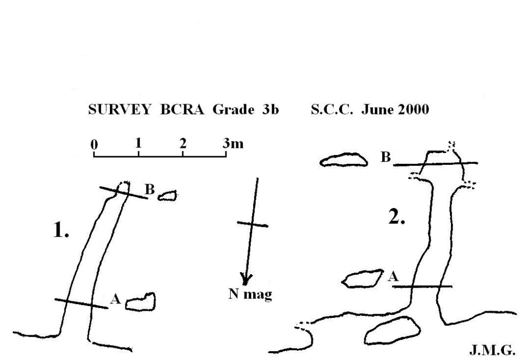
Obvious “Roulston Scar type” fissure whose entrance is partially blocked by a dry stonewall.

History
Known locally, first noted by an S.C.C. /A.C.C. team in February 1999.

NOT OXENDALE WINDYPIT
Length: 15 m
Depth: 6 m
Grade: II
Entertainment value: II

Warning: Beware loose rock and broken glass in the entrance.

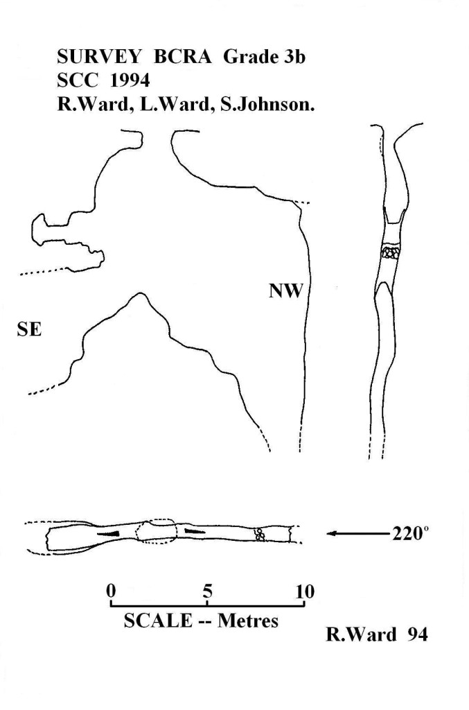
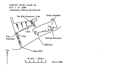
This rather short interesting hole is not easy to find: To the west of Oxendale Fissure lies a rubbish heap, 5 m beyond you come to an open fissure with a tree growing in the entrance. Follow this fissure until a rather grotty, unstable looking hole is found at the foot of a climb.

Drop down through the hole, Straight ahead is a short, flat out crawl under a poised boulder leading into a constricted boulder chamber with no way on. To the right one enters a low, roomy bedding type chamber with a
narrow rift along the south wall. Drop into the rift at the widest point and on into a small chamber. In the floor of the chamber is a very narrow rift. A tight squeeze down through the rift (larger cavers will experience major problems here, especially on the return) opens into a roomy chamber 4.5 m long and up to 7.5 m high. For those too fat to get back up the rift there is a rather sneaky back door: Climb up into the roof of the chamber at its highest point where a letterbox opens up onto the cliff face, an easy climb brings one back down to terra firma.

History
Discovered and dug by a joint S.C.C./ A.C.C. team between February and March 1999. The rather odd name resulted from heated discussions between two of the original explorers; one of whom wanted to call it Oxendale Windypit, the other didn’t. “Not Oxendale Windypit” emerged as something of a compromise!
mc=oxen

Nunnington Railway Cutting

Moorland Caver (2003)

Discovered late 1860s / early 1870s during the construction of a railway cutting through the Caulkless Spur. Continuing work during the construction of the cutting obscured the cave. The cave consisted of a large chamber with a strong draught. Three fissures led off, one apparently containing a pitch with the sound of running water beyond. It is likely that the main chamber was quarried away during further work in the cutting; however the possibility remains that the fissures survive.

Nunnington

Newclose Rigg Pot (Stump Grinder Pot)

Moorland Caver (2003)

NGR:SE 869894
Altitude: 200m
Length: 15m
Depth: 20m
Access: Forestry Commission
Grade: I
Entertainment Value: II

Obvious fenced entrance around a loose body sized hole (might require some gardening).
Restricted (0.6m wide) pitch of 6m to a ledge at the top of a rubble cone is free climbable but is best hand lined or laddered (preferred) and belayed to a fence post.
NW the fissure tightens and ends but SE, the rift continues (although tight) and remains unexplored.

History
Discovered by forestry commission

Tackle
10m ladder and short belay

mc-stump

Nanny Coopers Hole

Moorland Caver (2003)

NGR: SE 553804
Altitude: 230m
Length: 6m
Access: Not known
Grade: I

On East side of Duckendale, in cliff face, 50m South of Duckendale Windypit.
Entrance is narrow fissure at right angles to cliff entering small chamber after short distance.